Flood Hazard Mapping of North-Western Part of Bangladesh Using Geographic Information Tools
H. M. Rasel, Prosenjit Datta, Rana Sarker, ABM Shafkat Hossain, Md. Sohel Rana
Abstract
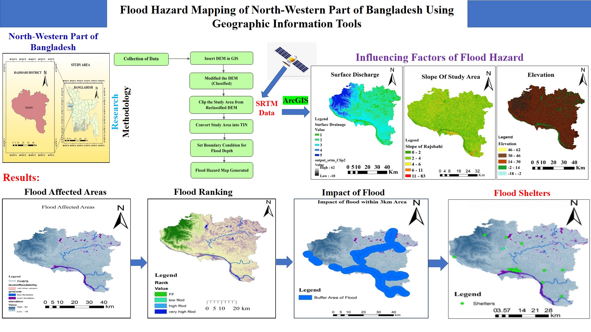
Bangladesh is a country prone to flooding. Each and every year flood has occurred during rainy season in Bangladesh at some district mainly coastal area, haor basin, Ganges river basin, Brahmaputra river basin, Jamuna river basin, Meghna river basin etc. One of the famous districts of Bangladesh is Rajshahi district, because of the bad impact of the river flood. River floods carry sediment which deposits over the bed of the river and decrease the depth of the flow water. A flood hazard map will be developed in this study to help the peoples of Rajshahi district during the river flood to keep them safe from the disaster. This study will compile the factors for flood vulnerability, predicting the future flood scenario along with a list of recommendations for good institutional arrangements in the study area, so that disadvantaged people can receive assistance in a timely and effective manner during the flood. Geographic Information System (GIS) tool of version 10.8 is used in this study. To do as such, use SPOT and SRTM DEMs information for which precision evaluation is accomplished by utilizing actually take a look at focuses. The significant findings of this study demonstrate that river flooding occurs every year, especially 15 to 20 days before harvesting, as well as it is a highly dangerous event in the lives of the inhabitants in this area. Finally, in ArcMap, all of the data is integrated to provide a final flood hazard map for the research area.
Conclusion
A single model flood map and GIS technique were used to evaluate inundation hazard for the Ganges River floodplain. The findings of the study provide a method for measuring the prospect for flooding in the research area, which may be used to predict the damaging effects of impending floods. Flood hazard assessments were accepted, and flood hazard maps for the research region were created using a model simulated flood depth map from 2019. The inundation hazard maps generated for each administrative Upazilla. These categories of map support the appropriate persons for well realize the flood behaviour of the flood affected area.
The outcomes discussed of their search deliver very important evidence for inundation monitoring progress, and the formation and progress of flood measurement in the utmost flood hazardous zone in Ganges River floodplain. The most flood-prone Upazilla in the study region, according to map of flood hazard on the administrative unit map are Bagmara, Bagha, and Charghat due to the inundation of the Ganges river floodplain, whereas Tanore, Paba, Boalia, and Mohonpur are less flood-prone. For the flood affected areas several numbers of institutional building and other infrastructures are chosen that have potential to be used as shelter house during severe flood. A shelter was thought to be an existing school, hospital, or government building.
The Ganges River floodplain has a very high flood extent. As a result, early warning systems and mitigating measures must be implemented in these locations. As a result, policymakers and development planners can use the findings of this study to develop appropriate early warning systems and flood mitigation measures, reducing the effects of flooding on the livelihoods of rural small holder farmers in the study area by considering the area's spatial extent. This research provides crucial data that can help decision-makers prioritize development initiatives at the local government level. Based on the findings of this case study for the Rajshahi District, it is possible to draw the conclusion that geospatial technology offers the best potential for analysis and the provision of data necessary for efficient decision-making regarding floods. ArcGIS Model Builder's complete flood hazard and shelter model is simple enough for GIS beginners to use.
References
[1]
Atay, I., Tuvan, A., Demir, O. and Batla, I. Iklam degisikliginin saglik uzerine etkileri. T.C. Orman ve Su Isleri Bakanligi Meteorologji Genel Mudurlugu, Ankara: 2012.
[2]
Baky, A.A., Zaman, A.M., Khan, A.U. (2012) Managing flood flows for crop production risk management with hydraulic and GIS modeling: case study of agricultural areas in Shariatpur. APCBEE Procedia 1:318–324.
[3]
Bapalu, G. V., and Sinha, R. (2003). GIS in flood hazard mapping– A case study of Kosi river basin, Kanpur, India. Geology, vol. 15, no. 3, pp. 204–207.
[4]
Bhuiyan, M., Dutta, D. (2012). Analysis of flood vulnerability and assessment of the impacts in coastal zones of Bangladesh due to potential sea-level rise. Nat Hazards 61:729–743
[5]
Bhuiyan, M.S.R., (2014). Flood Hazard and Vulnerability Assessment in a Riverine Flood Prone Area: A Case Study. Bangladesh University of Engineering and Technology (BUET).
[6]
Brammer, H., and Khan, H., (1991). Bangladesh case study. In: Disaster mitigation in Asia and the Pacific, Asian Development Bank, Manila.
[7]
Brunner, G.W., Piper, S.S., Jensen, M.R., and Chacon, B., (2015). Combined 1D and 2D Hydraulic Modeling within HEC-RAS. World Environ. Water Resource Congress. 1432–1443. https://doi.org/
https://doi.org/10.1061/9780784479162.141
[8]
Burt, T., Bates, P., Stewart, M., Claxton, A., Anderson, M. and Price, D (2002). Water Table Fluctuations within the Floodplain of the River Severn, England, <em>Journal of Hydrology 262(1-4)</em>, pp. 1– 20.
[9]
Chandran, R., and Joisy, B. M. (2009). Flood hazard mapping of Vamanapuram river basin. in Proc. 10th National Conference on Technological Trends (NCTT09), Trivandrum, Kerala, pp. 126–131.
[10]
Chowdhury, J., Rahman, M., Salehin, M. (1997). Flood control in a floodplain country: experiences of Bangladesh, <em>Institute of Flood Control and Drainage Research Publication of the Islamic Education Scientific and Cultural Organization (ISESCO)</em>, Rabat, Morocco.
[11]
Das, S., and Pardeshi, S. D. (2018). Morphometric analysis of Vaitarna and Ulhas river basins, Maharashtra, <em>India: using geospatial techniques. Applied Water Science</em>, 8, 158. https://doi.org/
https://doi.org/10.1007/s13201-018-0801-z
[12]
Da-wei, Z; Jin, Q; Hong-bin, Z; Fan, W; Hong, W; Xiao-yan, H (2015). Flash flood hazard mapping: A pilot case study in Xiapu River Basin, <em>China. Water Science and Engineering</em>, Volume 8, Issue 3, pp. 195–204.
[13]
Dilley, M., Chen, R.S., Deichmann U., Lerner-Lam A.L., Arnold M., Agwe J., Buys P., Kjevstad O., Lyon B., and Yetman G., (2005). Natural disaster hotspots: a global risk analysis. World Bank.
[14]
Donnelly, K., and Maidment, D. (2001). Developing digital flood insurance rate maps for Lago Vista. CRWR Technical Report, UT. V. K. Sharma, “Use of GIS related technologies for managing disasters in India: An overview.”
[15]
Eimers, J., Weaver, J., Terziotti, S. and Midgette, R. (2000). Methods of rating unsaturated zone and watershed characteristics of public water supplies in north-Carolina. Water Resources Investment Report, Raleigh, NC, 99–4283.
[16]
Elkhrachy, I. (2015). Flash Flood Hazard Mapping Using Satellite Images and GIS Tools: A case study of Najran City, <em>Kingdom of Saudi Arabia (KSA). The Egyptian Journal of Remote Sensing and Space Science</em>, Volume 18, Issue 2, pp. 261–278.
[17]
Elmira, B. (2016). Developing a flood risk map a case study of the city of Pori. Finland.
[18]
Feldman, A. D. and Owen, H. J. (1997). Communication of Flood-risk Information: Hydrology and Hydraulic Workshop on Risk Based Analysis for Flood Damage Reduction Studies. USACE, California, USA.
[19]
Fernández, D. S., and Lutz, M. A. (2010). Urban flood hazard zoning in Tucumán Province, Argentina, <em>using GIS and multicriteria decision analysis. Engineering Geology</em>, 111, 90–98.
[20]
Forkuo, <em>E. K. (2011). Flood Hazard Mapping Using ASTER Image Data with GIS. International Journal of Geomatics and Geosciences</em>, Volume 1, Number4, pp. 932-950.
[21]
Forkuo, E. K., and Tsawo., <em>V. A. (2013). The use of Digital Elevation Models for Watershed and Flood Hazard Mapping. International Journal of Remote Sensing & Geoscience</em>, Volume 2, Issue 2, pp. 56-65.
[22]
Fosu, C., Forkuo, E. K., and Asare, M. Y. (2012). River Inundation and Hazard Mapping-A Case Study of Susan River, <em>Proceedings of Global Geospatial Conference</em>, Québec City, Canada,14-17 May,16p.
[23]
Gruntfest, E. and Handmer, J. (2001). Coping with Flash Floods, Kluwer Academic Publishers Netherlands, ISSN 0-7923-6825-8, pp. 11-13.
[24]
Hausmann, P. and Weber, M. (1998). Possible Contributions of Hydro informatics to Risk Analysis in Insurance, In Proceeding of 2nd International Conference on Hydro informatics, Zurich, Switzerland, 9–13 September, Balkema, Rotterdam.
[25]
Hoque, R., Nakayama, D., Matsuyama, H., Matsumoto, J. (2011). Flood monitoring, mapping and assessing capabilities using RADARSAT remote sensing, GIS and ground data for Bangladesh. Nat Hazards 57:525–548.
[26]
Hutchinson, M. (1998). Interpolation of rainfall data with thin plate smoothing splines. II. Analysis of Topographic Dependence Describing or Pertaining to Special Regions, <em>Journal of Geographical Information and Decision Analysis; 2(2)</em>, 152–167.
[27]
International Union for Conservation of Nature and Natural Resources (IUCN) 2008. Introduction to Community based Haor and Floodplain resource management, IUCN Country Office, Bangladesh, Dhaka.
[28]
Islam, A., Bala, S., Haque, M. (2010). Flood inundation map of Bangladesh using MODIS time-series images. J Flood Risk Manag 3:210–222
[29]
Johnson, C.A., Yung, A.C., Nixon, K. R. and Legates, D.R. (2011). The use of HEC-GeoHMS and HECHMS to Perform Grid-Based Hydrologic Analysis of a Watershed, Dodson & Associates, Inc. - Houston, Texas, USA, 2001. Available at http://www.dodson-hydro.com. Data Accessed: 05/03/11.
[30]
Karimi, H. A. and Houston, <em>B. H. (1996). Evaluating Strategies for Integrating Environmental Models with GIS: Current Trends and Future Needs. Journal of Computer</em>, Environment and Urban Systems, vol. 20, pp. 413-425.
[31]
Kourgiala, N. and Karatzas, <em>G. (2011). Flood management and a GIS modelling method to assess flood-hazard areas - a case study. Hydrological Sciences Journal; 56(2)</em>, 212-224.
[32]
Islam, M. M., <em>and Sado. K. (2000). Development of flood hazard maps of Bangladesh using NOAA-AVHRR images with GIS. Hydrological Sciences Journal</em>, vol. 45, pp. 337–356.
[33]
Mirza, M.M.Q. (2011). Climate change, flooding in South Asia and implications. Region Environ Change 11:95–107.
[34]
Mojaddadi, H., Pradhan, B., Nampak, H., Ahmad, N., Ghazali, A.H.B. 2017. Ensemble machine-learning-based geospatial approach for flood risk assessment using multi sensor remote sensing data and GIS. Geo mat Nat Hazards Risk. 8(2):1080–1102.
[35]
Nicholls, R. (2002). Analysis of Global Impacts of Sea-Level Rise: A Case Study of Flooding, Physics and Chemistry of the Earth 27, pp. 1455–1466.
[36]
Ohl, C., and Tapsell, S. (2000). Flooding and Human Health: The Dangers Posed Are-not Always Obvious, British Medical Journal 321.
[37]
Punithavathi, J., Tamilenthi, S., and Baskaran. (2011). Flood zone mapping of Thanjavur district, <em>Tamilnadu using GIS. Advances in Applied Science Research</em>, vol. 2, no. 2, pp. 437–449.
[38]
Rahmati, O., Zeinivand, H., &Besharat, M. (2016c). Flood hazard zoning in Yasooj region, Iran, using GIS and multi-criteria decision analysis. Geomatics, Natural Hazards and Risk, 7, 1000–1017. https://doi.org/
https://doi.org/10.1080/19475705.2015.1045043
[39]
Rouf, T. (2015). Flood inundation map of Sirajgonj district using mathematical model. MSc Thesis. Bangladesh University of Engineering and Technology (BUET). Dhaka.
[40]
Samanta, S., Pal, D. K., &Palsamanta, B. (2018). Flood susceptibility analysis through remote sensing, <em>GIS and frequency ratio model. Applied Water Science</em>, 8, 66. https://doi.org/10.1007/ s13201-018-0710-1
[41]
Sanyal, J., and Lu, X. X. (2006). GIS-based flood hazard mapping at different administrative scales: A case study in Gangetic West Bengal, <em>India. Singapore Journal of Tropical Geography</em>, vol. 27, pp. 207–220.
[42]
Seker, D. and Kabdasli, S. Kıyılardaki dogal felaketler icin risklerin cbs ile analizi ve risk haritalarıinin uretilmesi, Selcuk Universitesi Jeodezi ve Fotogrametri Muhendisligi Ogretiminde 30. yil Sempozyumu, Konya, 16-18 October 2002, Selcuk University, pp. 322-332.
[43]
Seyedeh, S. S., Thamer, A. M., Mahmud, A. R. B., Majid, K. K., and Amir, <em>S. (2008) Integrated Modelling for Flood Hazard Mapping Using Watershed Modelling System</em>, American Journal of Engineering and Applied Sciences 1 (2): pp. 149-156.
[44]
Shaban, A., Khawlie, M., Abdallah, <em>C. (2006). Use of remote sensing and GIS to determine recharge potential zones: the case of occidental Lebanon. Hydrogeology Journal; 14(4)</em>, 433-443.
[45]
Smith, K. (1996). Environmental Hazards: Assessing Risk and Reducing Disaster, 2nd ed. London, England: Routledge.
[46]
Tehrany, M.S., Kumar, L. 2018. The application of a Dempster–Shafer-based evidential belief function inflood susceptibility mapping and comparison with frequency ratio and logistic regression methods. Environ Earth Sci. 77(13):490.
[47]
Tehrany, M. S., Lee, M.-J., Pradhan, B., Jebur, M. N., & Lee, <em>S. (2013). Flood susceptibility mapping using integrated bivariate and multivariate statistical models. Environment and Earth Science</em>, 72, 4001–4015. https://doi.org/
https://doi.org/10.1007/s12665-014-3289-3
[48]
Walesh, G. S. (1989). Urban Surface Water Management. Chichester, USA: John Wiley & Sons Ltd.
[49]
Winterbottom, S. J. and Gilvear, D. J. (2000). A GIS-based approach to mapping probabilities of river bank erosion: regulated River Tummel, <em>Scotland. Regulated Rivers: Research & Management</em>, vol. 16, pp. 127-140.
[50]
Yahaya, S, Ahmad, N. and Abdalla, R. (2010). Multicriteria analysis for flood vulnerable areas in hadejia-jama’are river basin, <em>nigeria. European Journal Scientific Research; 42(1)</em>, 71-83.
[51]
Yang, X., and Rystedt, B. (2002). Predicting flood inundation and risk using GIS and hydrodynamic model: A case study at Eskilstuna, Sweden. Indian Cartographer, vol. 22, pp. 183–191.
[52]
Youssef, A.M., and Pradhan, B. (2011). Flash flood risk estimation along the St. Katherine road, Southern Sinai, Egypt using gis based morphometry and satellite imagery. Environ. Earth Sci. 62 (3), 611–623.